This content is still in development or in editorial
review.
Type: Backcountry or Sidecountry
Overview
The couloir at Gibraltar Lakes goes by numerous names: Strait of Gibraltar, Gibraltar Lakes Couloir, etc. Being one of the "St Vrain Glaciers", it is a perennial couloir, and one of the few true couloirs in the state of Colorado that doesn't melt out (in an average year, at least). In Fall, this route goes as a snow/ice climb (up to AI II).
Need to Know
For parking, America the Beautiful pass must be on your dash or pay the onsite $10 day parking pass. Parking lot is located at the very end of the campground. Large lot.
Description
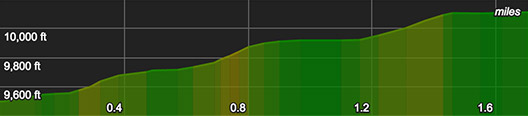
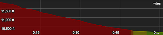
It may be a long 19 mi round trip, but it's still a grade 3 route (long day without overnight required) since the approach is only 3k vert (the couloir itself is 1.1k vert). If one were to camp, many other decent routes exist within the St Vrain Glaciers, but the most obvious nearby steep lines in the area are "Dalkes Couloir" (off Ogalala Peak) and another couloir off Elk Tooth Peak (sometimes known as "The Snake"). Both are a stone's throw from the Strait although both aren't perennials.
Approach from Middle St Vrain Trailhead (Camp Dick)
Start at Camp Dick, stay on the trail (don't hike the road; it's swampier and much rockier). Turn a right at the St Vrain Glaciers turn-off (which has a wooden sign), then follow that to Gibraltar Lakes. If you accidentally passed this sign without turning right, you'll know immediately because you'll come to a long built log bridge; turn around until you find the small wooden sign for the "St Vrain Glaciers". After you take this right, you'll eventually come to a small boulder field (on the right), where the trail will lead you left down to the river. You'll walk 1 or 2 minutes along the river until you see a pile of logs for crossing the river (which isn't a proper bridge, but they are stable). This is the only necessary river crossing, but you may cross a few low streams after this depending on the time of year.
Alternate Approach from Beaver Park Dam
This trailhead avoids the $10 parking fee if you don't have the America the Beautiful pass that the TH at Camp Dick requires. However, this approach doesn't save any time since it starts a bit further south. Additionally, the views are far more limited here, where as the Middle St Vrain trail provides views of the gorgeous cliffs to the north of the trail at many points. Beaver Park Dam also requires a bit more route finding, since you'll cross with the road and you need to take the link-up trail to get over to the St Vrain Glacier trail. It's best to save Beaver Park Dam for any attempts at more southern routes, such as the Sawtooth or the Paiute lines near Coney Lake.
Couloir
Using the Lou Dawson "D" scale, this line goes as either a D11 and D12 depending on the snow year. R3 - R4 depending on how much cornice and apron is in-tact. The couloir itself above the apron is an average of 40 degrees. The top quarter steepens to 45 and has a 50 degree drop-in. It's a decently wide couloir; you aren't very constricted, but this also isn't a highway of a route (like the main gut of Dragon's Tail).
Cornice
It does hold a sizable cornice. The center may hold throughout summer, whereas looker's right cornice can be dangerous since it sits precariously on a cliff top and will eventually fail. Cracks have been observed on top here.
Looker's left is fortunately not corniced much at all and allows for exit and re-entry. Most of the couloir has sections on climber's left to allow you to mitigate cornice hazard if you're there in Spring, and you may opt to start climbing your way left through some rock bands near the top to avoid the last bit of exposure to cornice. Otherwise, summer will of course provide safer mitigation. It does develop a runnel down the center by late Spring, but the couloir is wide enough that this doesn't constrict the line too much.
Fall
This couloir can be climbed in October & November before a persistent weak layer settles in. The top 90% of the couloir holds a lot of windload. Once you climb past the ice-covered small rock band near the top, it doesn't hold as much new snow due to its steepness (upper 40s with a max around 50 degrees), so you may experience thin black ice until you reach the foundation of what's normally the cornice, which can be made up of primarily blue ice.
Shared By:
Ryan L

 Continue with onX Maps
 Sign in with Facebook








 Very Difficult





 All Clear






0 Comments