Powder Project Logo

This is an aerobic route across an alpine ridge above a series of steep avalanche paths.


Your Rating: Rating Rating Rating Rating Rating      Clear Rating
Your Difficulty:
Your Favorites: Add To-Do · Your List
Zoom in to see details
Map Key

3.7

Miles

6.0

KM

Ascent

12,226' 3,726 m

High

10,226' 3,117 m

Low

2,104' 641 m

Up

105' 32 m

Down

11%

Avg Slope (6°)

31%

Max Slope (17°)
Type: Backcountry or Sidecountry
This is a wilderness area, so no mechanized equipment, drones etc.

Description

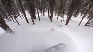
Head about 0.3 miles up the Long Canyon trail to where it levels by the stream, about a hundred feet past the new Columbine-Hondo Wilderness sign. Find any of the natural bridges created by fallen trees across the stream and begin making ascending switchbacks through the forest. A few hundred vertical feet up, the terrain steepens as it leads to the ridge and the top of the Snowshoe Approach. Enjoy the open views here, then start the climb to the northwest across a series of steps and peaks above various small forested bowls and slide paths. The route leads to a large rock outcrop, which is an important landmark—beyond here, the terrain becomes steeper and more avalanche prone. Continue above some north-facing, forested chutes to the top of the first open slide path. Here the route aims more north and crosses above several larger, open, east-facing avalanche paths on the long climb to the summit point. By now it will be obvious why this is named Avalanche Ridge. North of the summit, the route continues as it crosses the broad, south-facing bowl at the head of Long Canyon.

Contacts

Shared By:

J. Bella

Trail Ratings

  5.0 from 1 vote

#1

in Taos

#64

Overall
  5.0 from 1 vote
5 Star
100%
4 Star
0%
3 Star
0%
2 Star
0%
1 Star
0%
Ascent Rankings

#1

in Taos

#1

in New Mexico

#64

Overall
2 Views Last Month
418 Since Feb 14, 2018
Difficult Difficult

0%
0%
0%
0%
100%
0%

Photos

Avalanche Ridge
Feb 15, 2018 near Taos Sk…, NM
South view from Avalanche Ridge, Long Canyon's west ridge ~ Frazer Mountain, Wheeler Peak, West Simpson, Sin Nombre, Fairview and Kachina Peak.
Dec 17, 2018 near Taos Sk…, NM
Cornice and giant avalanche crown at the top of King Kong. This slide occurred January 20th, 2018 and the picture was taken a week later.
Feb 4, 2019 near Taos Sk…, NM
A very large slab released on Avalanche Ridge during March 2019, pic from the top of the Bong Chute March 20th
Apr 3, 2019 near Taos Sk…, NM
Trail to the Snowshoe Couloir
Jan 28, 2018 near Taos Sk…, NM
Asteroid Belt in Long Canyon, December 2018
Dec 30, 2018 near Taos Sk…, NM

0 Comments

Weather


Current Trail Conditions

Unknown
Add Your Check-In

Check-Ins

none

Join the Community

Create your FREE account today!
Already have an account? Login to close this notice.

Get Started.