Type: Backcountry or Sidecountry

Lick Creek road is closed in the winter months to normal vehicle traffic. Snow cats or snowmobiles are permitted and unless you are a real "beast," the only sane way to get to the base. The trip in is 10+ miles.

Need to Know
It is best to make this a multi-day adventure and book the Lick Creek Yurts, operated by Payette Powder Guides.
Description
You are almost guaranteed to have untracked snow on this peak, due to the remoteness. Even most people who ski from the Yurts tend to ski the terrain immediately around them. We had nice powder that was from a storm 5 days earlier.
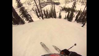
This descent from the summit starts on a south facing ridgeline and then drops into a steep face at the saddle. By staying close to the "Wall," the huge cliff on skiers right, we had powder that was not sun-baked. You can ski all the way back to the Lick Creek Road, and then skin back up to the yurts.
The ridge tends to be what a lot of south facing ridges in this area would be; lots of rocks and wind blown snow. We timed it right and had spring-corn like conditions in Feb. The fun really starts when you drop off the ridge and head down the face. The closer you stay to the "The Wall", skiers right, the safer you'll be. As you venture left, you'll encounter cliff bands, terrain traps and rollovers that all pose risk with the reward of adrenaline that you may be seeking.
After the 1500' vertical of "steep" skiing, you'll have some easy, varied terrain down to lick creek road, (about 800 vertical). There are big rocks/small cliffs to watch out for in this area, as well as a lot of fallen logs from fires that burned a few years ago. These are fun terrain features, but they can surprise you if you aren't staying alert.
There are several alternatives to this descent and if you spend a full day on the peak, you could easily get 2-3 laps of chutes, bowls, and for the adventurous, some moderate to committed cliff bands to play in.
History & Background
This peak is the primary feature that you look at as you set on the deck of the PPG Yurts. Their logo is an artists rendition of the peak, as seen from the yurts.
Contacts
Shared By:
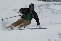
Cody Feuz

 Continue with onX Maps
 Sign in with Facebook


 Difficult

 4.5 (2)


0 Comments