Type: Backcountry or Sidecountry
Need to Know

SHB gives more intel to their members about the Finland Project on their website - superiorhighlandbc.org
Description
Started the day parking at the Superior Hiking Trail Parking lot, we threw on our skins and had to navigate over the sizable snowbank left by the plow guy after a recent 20+ inch Spring dump over the last three days. Our ascent began on the rolling terrain of the SHT, we encountering two creeks crossings with bridges, already somewhat precarious, were further compromised by the weight of the recent heavy snowfall. Normally, these creeks would be frozen, but spring conditions were present.
After the second river crossing, we reached a prominently marked gate/kiosk where we took a RIGHT as directed by the clear signage. Superior Highland Backcountry maintains a logbook. We made a donation via Venmo using the QR code on the kiosk. They maintain and clean up the lines in the fall. Without their efforts, it's doubtful the terrain would be as rideable as it is.
Continuing on, we eventually reached the Summit Access trail, which circumnavigates the main topographic face. The summit typically offers a stunning vista on a clear day, but unfortunately, cloudy conditions obscured the view.
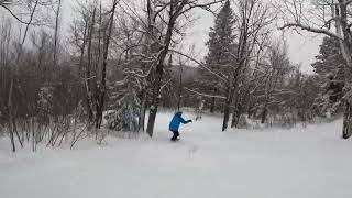
We hit the steepest terrain and were thoroughly impressed. It offered around 10-15 challenging turns that got our legs burning. Upon skiing down, we made a sharp right turn to rejoin the Summit Access trail. We completed this loop seven times, leaving us totally exhausted.
Additionally, we stumbled upon a 8ish foot natural cliff kicker and took turns hitting it multiple times. We had to clear some fallen tree debris from the landing, but it was a solid landing zone.
Returning to the parking lot required some effort, but it was manageable. For those seeking a gentler descent, the skier's left offers the easiest route down, clearly marked for visibility. Just be sure to maintain your speed to avoid getting stuck in certain areas.
Having such public access backcountry terrain in Minnesota is pretty remarkable. And with a fresh 20-inch dump, the tour up was absolutely worth it!
Contacts
Shared By:
Feisty Caravan

 Continue with onX Maps
 Sign in with Facebook


 Intermediate/Difficult


0 Comments