Powder Project Logo

One of the must-visit places of Armenia.


Your Rating: Rating Rating Rating Rating Rating      Clear Rating
Your Difficulty:
Your Favorites: Add To-Do · Your List
Zoom in to see details
Map Key

5.2

Miles

8.4

KM

Ascent

9,451' 2,881 m

High

6,308' 1,923 m

Low

3,154' 961 m

Up

41' 12 m

Down

12%

Avg Slope (7°)

78%

Max Slope (38°)
Type: Backcountry or Sidecountry

Description

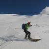
The trail, which is located in Kotayk region 73 km from Yerevan, is passable in January, February, March, and even as late as mid-April (up to April 15). The ski run starts from the last residence in Meghradzor town. The mountain is also interesting for hiking. The water reservoir of Hankavan is also visible from the Mount. The ski run of Mount Artavaz passes through the canyon, along Marmarik River, and then climbs sharply. This section is dangerous with the snowstorms, and it is advised to follow the trail without going off road. The most beautiful scenes will open up around you from the peak areas.

Shared By:

State Tourism Committee Repub…

Trail Ratings

  5.0 from 1 vote

#1

in Meghradzor

#103

Overall
  5.0 from 1 vote
5 Star
100%
4 Star
0%
3 Star
0%
2 Star
0%
1 Star
0%
Ascent Rankings

#1

in Meghradzor

#8

in Armenia

#103

Overall
1 Views Last Month
27 Since Jan 26, 2018
Intermediate Intermediate

0%
0%
100%
0%
0%
0%

Photos

Skiers on the Mount
Feb 14, 2018 near Meghradzor, AM
The Peak of Mount Artavaz
Feb 21, 2018 near Meghradzor, AM
The fascinating view of Mount Artavaz
Feb 14, 2018 near Meghradzor, AM
Climbing a steep section.
Dec 19, 2017 near Meghradzor, Not set (Republic of Armenia)

0 Comments

Current Trail Conditions

Unknown
Add Your Check-In

Check-Ins

none
Welcome

Join the Community

Create your FREE account today!
Already have an account? Login to close this notice.

Get Started