Type: Backcountry or Sidecountry
Description

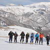
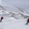
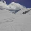
Teghenis Mountain is located on the border of the Aragatsotn and Kotayk provinces. To start skiing on the slopes of the mountain, you need to set off to Shoghakn village, which is typically covered by 1-2 meters of snow in January and February. The skiing trail begins at the edge of the village and leads up to the nearby hill. The slopes of Mount Teghenis are covered with birches, firs, and Siberian pine trees.
From the top of the mountain, you can admire the beautiful mountains of the Armenian Plateau: Pambak Mountain in the north, Mount Ara in the south, the Geghama Mountains in the east, Aragats in the west, and Ararat in the southwest. An aeration center operates on the top of Mount Teghenis and is inhabited throughout the year.
Shared By:
State Tourism Committee Repub…

 Continue with onX Maps
 Continue with Facebook


 Intermediate


0 Comments